The Royal Oak Halloween Home Map: How It Started and How to Use It
- Kathleen Spangler
- Oct 19, 2025
- 3 min read

How We Got Here: The Royal Oak Halloween Home Map Story
A few years ago, I noticed something fun happening on our community Facebook page. People were posting photos of their Halloween-decorated homes, and my family would write them down so we could visit them. Keeping track got messy, and one night it hit me, why not just put them all on a map? A simple Google Maps solution later, and our first Royal Oak Halloween Home Map was born. It was easy, useful, and I quickly realized other families might want it too.

The next year, I made it official. I posted in the community group asking people to send me a photo of their home and the address. Why a photo? Because I don’t reject any homes, but not every house is “kid-friendly.” Some are spooky, some are funny, and some go all out. A photo helps families decide what they’re walking into before they get there. Fair is fair.
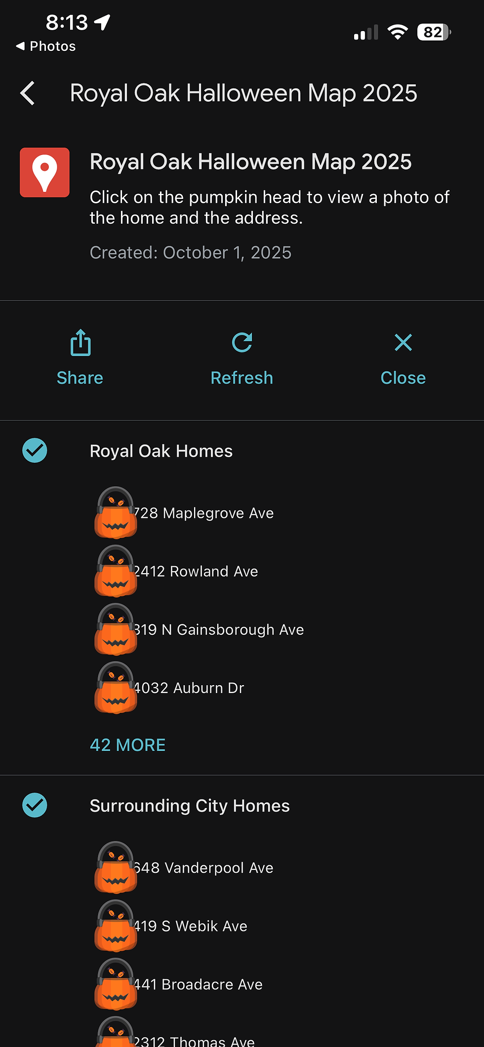
What the Map Looks Like
The map itself is simple. Each participating home is marked with a small custom icon I upload. This year, it’s a little pumpkin trick-or-treat basket, easy to spot, festive, and way better than a boring default Google pin.

How the Map Has Grown
Every single year, the map gains more traction. I started by posting it only on community Facebook pages. Then I shared it on my own page. A few years later, I worked with the school district so they could email it out to every family. Last year, the city shared it on their social media.
And this year, I’m reaching out to local websites and influencers who post about things to do in the area each weekend. I like to take things one step at a time, so I can see what actually works before adding something new.
As a marketing director, creating awareness is what I do for a living, so even though this isn’t about selling anything, it’s about building a small experience for the community. And being a graphic designer doesn’t hurt either; I can design any map assets, flyers, or graphics that help spread the word.
How to Use the Map
The map lives on Google Maps. I highly recommend using the Google Maps app, not just a web browser. The app lets you:

It’s simple, visual, and designed for anyone who wants to explore the best Halloween decorations in Royal Oak.
How to Access the Map Using the QR Code
If you’re using a printed flyer, yard sign, or digital post with the QR code, here’s how to open it:On your phone, click and hold the QR code. A pop-up will appear giving you the option to open in your browser (like Safari) or directly in Google Maps. I strongly suggest using Google Maps, it’s more intuitive and gives you the full experience with the map legend and house details.

How Homes Are Submitted
People send me their photo and address either through email or Facebook Messenger. I usually add homes within 24 hours of receiving them, especially as Halloween gets closer and excitement builds.
Why the Map Works
It’s free, family-friendly, and gives everyone a chance to enjoy something creative and local. It shines a light on the people who go all out decorating their homes and gives families a reason to get out, explore, and make new Halloween traditions.
What’s Next
Next year, I’m planning to print a few yard signs with a reusable QR code that can easily be swapped out annually. I might also put flyers at local spots like the library or businesses where families go. And since my kids’ school does a trunk-or-treat every year, I might even hand out cards with the map so families can take it home with their candy.
If you want to check out this year’s map, click here
Share the Map!
Please feel free to use any of these documents/files for sharing on your site or social media account:

Comments